|
|
|||||||||||||||||
| Point ID: 429 | Downloads | Plots | Site Data | Code: 05CJ008 |
|
|
|||||||||||||||||
| Download | |
|---|---|
| Site Descriptor Information | Site Time Series Data |
| Link to all available data | |
| View: | Time Series | All |
| Units: | mm |
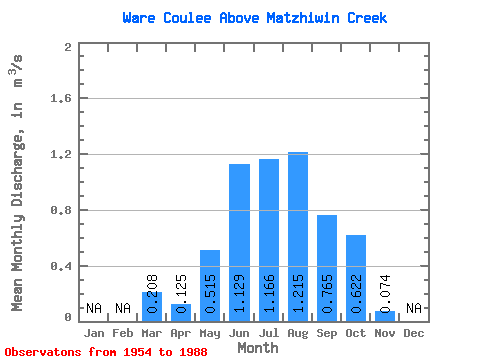
| Statistic | Jan | Feb | Mar | Apr | May | Jun | Jul | Aug | Sep | Oct | Nov | Dec | Annual |
|---|---|---|---|---|---|---|---|---|---|---|---|---|---|
| Mean | 0.21 | 0.12 | 0.52 | 1.13 | 1.17 | 1.22 | 0.77 | 0.62 | 0.07 | ||||
| Standard Deviation | 0.10 | 0.08 | 0.22 | 0.59 | 0.61 | 0.56 | 0.36 | 0.29 | 0.02 | ||||
| Min | 0.14 | 0.07 | 0.13 | 0.36 | 0.23 | 0.12 | 0.07 | 0.14 | 0.05 | ||||
| Max | 0.28 | 0.22 | 1.12 | 2.89 | 3.09 | 2.85 | 1.57 | 1.34 | 0.09 | ||||
| Coefficient of Variation | 0.48 | 0.66 | 0.42 | 0.52 | 0.52 | 0.46 | 0.47 | 0.47 | 0.24 |
 Return to R-Arctic Net Home Page