|
|
|||||||||||||||||
| Point ID: 429 | Downloads | Plots | Site Data | Code: 05CJ008 |
|
|
|||||||||||||||||
| Download | |
|---|---|
| Site Descriptor Information | Site Time Series Data |
| Link to all available data | |
| View: | Time Series | All |
| Units: | m3/s |
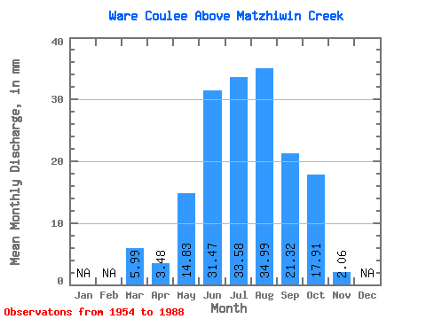
| Statistic | Jan | Feb | Mar | Apr | May | Jun | Jul | Aug | Sep | Oct | Nov | Dec | Annual |
|---|---|---|---|---|---|---|---|---|---|---|---|---|---|
| Mean | 5.99 | 3.48 | 14.84 | 31.46 | 33.59 | 35.00 | 21.32 | 17.91 | 2.06 | ||||
| Standard Deviation | 2.85 | 2.29 | 6.26 | 16.48 | 17.49 | 16.18 | 10.02 | 8.50 | 0.49 | ||||
| Min | 3.97 | 2.09 | 3.69 | 10.12 | 6.54 | 3.37 | 2.06 | 4.17 | 1.50 | ||||
| Max | 8.01 | 6.13 | 32.25 | 80.55 | 88.98 | 82.07 | 43.76 | 38.59 | 2.42 | ||||
| Coefficient of Variation | 0.48 | 0.66 | 0.42 | 0.52 | 0.52 | 0.46 | 0.47 | 0.47 | 0.24 |
 Return to R-Arctic Net Home Page