|
|
|||||||||||||||||
| Point ID: 428 | Downloads | Plots | Site Data | Code: 05CJ007 |
|
|
|||||||||||||||||
| Download | |
|---|---|
| Site Descriptor Information | Site Time Series Data |
| Link to all available data | |
| View: | Time Series | All |
| Units: | mm |
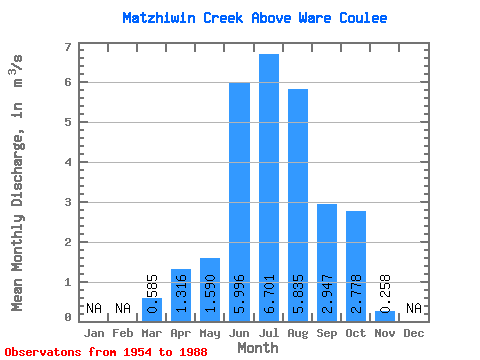
| Statistic | Jan | Feb | Mar | Apr | May | Jun | Jul | Aug | Sep | Oct | Nov | Dec | Annual |
|---|---|---|---|---|---|---|---|---|---|---|---|---|---|
| Mean | 0.58 | 1.32 | 1.59 | 6.00 | 6.70 | 5.83 | 2.95 | 2.78 | 0.26 | ||||
| Standard Deviation | 0.45 | 1.95 | 0.81 | 1.71 | 1.33 | 1.15 | 0.99 | 0.89 | 0.09 | ||||
| Min | 0.00 | 0.17 | 0.48 | 2.14 | 4.09 | 4.10 | 1.15 | 1.11 | 0.14 | ||||
| Max | 1.61 | 8.72 | 3.22 | 8.66 | 8.97 | 10.00 | 5.14 | 4.76 | 0.35 | ||||
| Coefficient of Variation | 0.76 | 1.48 | 0.51 | 0.28 | 0.20 | 0.20 | 0.34 | 0.32 | 0.36 |
 Return to R-Arctic Net Home Page