|
|
|||||||||||||||||
| Point ID: 428 | Downloads | Plots | Site Data | Code: 05CJ007 |
|
|
|||||||||||||||||
| Download | |
|---|---|
| Site Descriptor Information | Site Time Series Data |
| Link to all available data | |
| View: | Time Series | All |
| Units: | m3/s |
| Statistic | Jan | Feb | Mar | Apr | May | Jun | Jul | Aug | Sep | Oct | Nov | Dec | Annual |
|---|---|---|---|---|---|---|---|---|---|---|---|---|---|
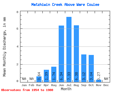
| Mean | 0.64 | 1.39 | 1.74 | 6.34 | 7.33 | 6.38 | 3.12 | 3.04 | 0.27 | ||||
| Standard Deviation | 0.49 | 2.06 | 0.89 | 1.81 | 1.45 | 1.25 | 1.05 | 0.97 | 0.10 | ||||
| Min | 0.00 | 0.18 | 0.53 | 2.26 | 4.47 | 4.48 | 1.22 | 1.21 | 0.15 | ||||
| Max | 1.76 | 9.22 | 3.52 | 9.16 | 9.80 | 10.93 | 5.44 | 5.20 | 0.37 | ||||
| Coefficient of Variation | 0.76 | 1.48 | 0.51 | 0.28 | 0.20 | 0.20 | 0.34 | 0.32 | 0.36 |
 Return to R-Arctic Net Home Page