|
|
|||||||||||||||||
| Point ID: 426 | Downloads | Plots | Site Data | Code: 05CJ005 |
|
|
|||||||||||||||||
| Download | |
|---|---|
| Site Descriptor Information | Site Time Series Data |
| Link to all available data | |
| View: | Time Series | All |
| Units: | mm |
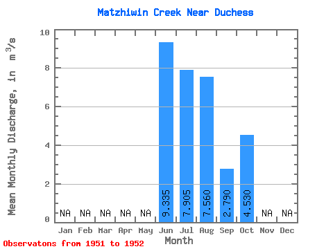
| Statistic | Jan | Feb | Mar | Apr | May | Jun | Jul | Aug | Sep | Oct | Nov | Dec | Annual |
|---|---|---|---|---|---|---|---|---|---|---|---|---|---|
| Mean | 9.34 | 7.91 | 7.56 | 2.79 | 4.53 | ||||||||
| Standard Deviation | 2.78 | 1.66 | 1.19 | 1.95 | |||||||||
| Min | 7.37 | 6.73 | 6.72 | 1.41 | 4.53 | ||||||||
| Max | 11.30 | 9.08 | 8.40 | 4.17 | 4.53 | ||||||||
| Coefficient of Variation | 0.30 | 0.21 | 0.16 | 0.70 |
 Return to R-Arctic Net Home Page