|
|
|||||||||||||||||
| Point ID: 426 | Downloads | Plots | Site Data | Code: 05CJ005 |
|
|
|||||||||||||||||
| Download | |
|---|---|
| Site Descriptor Information | Site Time Series Data |
| Link to all available data | |
| View: | Time Series | All |
| Units: | m3/s |
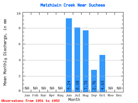
| Statistic | Jan | Feb | Mar | Apr | May | Jun | Jul | Aug | Sep | Oct | Nov | Dec | Annual |
|---|---|---|---|---|---|---|---|---|---|---|---|---|---|
| Mean | 9.23 | 8.08 | 7.73 | 2.76 | 4.63 | ||||||||
| Standard Deviation | 2.75 | 1.70 | 1.21 | 1.93 | |||||||||
| Min | 7.29 | 6.88 | 6.87 | 1.40 | 4.63 | ||||||||
| Max | 11.18 | 9.28 | 8.59 | 4.12 | 4.63 | ||||||||
| Coefficient of Variation | 0.30 | 0.21 | 0.16 | 0.70 |
 Return to R-Arctic Net Home Page