|
|
|||||||||||||||||
| Point ID: 390 | Downloads | Plots | Site Data | Code: 05CE005 |
|
|
|||||||||||||||||
| Download | |
|---|---|
| Site Descriptor Information | Site Time Series Data |
| Link to all available data | |
| View: | Time Series | All |
| Units: | mm |
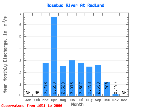
| Statistic | Jan | Feb | Mar | Apr | May | Jun | Jul | Aug | Sep | Oct | Nov | Dec | Annual |
|---|---|---|---|---|---|---|---|---|---|---|---|---|---|
| Mean | 2.78 | 6.63 | 2.53 | 3.07 | 2.81 | 2.49 | 2.64 | 1.21 | 0.19 | ||||
| Standard Deviation | 4.04 | 10.52 | 1.87 | 1.24 | 1.44 | 1.33 | 1.36 | 0.60 | |||||
| Min | 0.00 | 0.28 | 0.87 | 1.41 | 0.74 | 1.06 | 0.97 | 0.53 | 0.19 | ||||
| Max | 18.50 | 41.50 | 8.78 | 7.10 | 7.61 | 9.59 | 9.29 | 4.22 | 0.19 | ||||
| Coefficient of Variation | 1.45 | 1.59 | 0.74 | 0.40 | 0.51 | 0.53 | 0.52 | 0.50 |
 Return to R-Arctic Net Home Page