|
|
|||||||||||||||||
| Point ID: 390 | Downloads | Plots | Site Data | Code: 05CE005 |
|
|
|||||||||||||||||
| Download | |
|---|---|
| Site Descriptor Information | Site Time Series Data |
| Link to all available data | |
| View: | Time Series | All |
| Units: | m3/s |
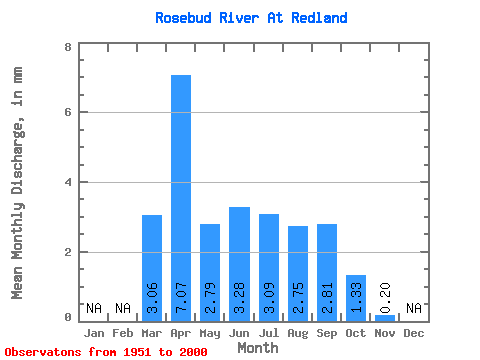
| Statistic | Jan | Feb | Mar | Apr | May | Jun | Jul | Aug | Sep | Oct | Nov | Dec | Annual |
|---|---|---|---|---|---|---|---|---|---|---|---|---|---|
| Mean | 2.08 | 4.80 | 1.89 | 2.23 | 2.10 | 1.86 | 1.91 | 0.91 | 0.14 | ||||
| Standard Deviation | 3.02 | 7.62 | 1.40 | 0.90 | 1.08 | 0.99 | 0.99 | 0.45 | |||||
| Min | 0.00 | 0.21 | 0.65 | 1.02 | 0.55 | 0.79 | 0.70 | 0.40 | 0.14 | ||||
| Max | 13.84 | 30.05 | 6.57 | 5.14 | 5.69 | 7.17 | 6.73 | 3.16 | 0.14 | ||||
| Coefficient of Variation | 1.45 | 1.59 | 0.74 | 0.40 | 0.51 | 0.53 | 0.52 | 0.50 |
 Return to R-Arctic Net Home Page