|
|
|||||||||||||||||
| Point ID: 379 | Downloads | Plots | Site Data | Code: 05CC011 |
|
|
|||||||||||||||||
| Download | |
|---|---|
| Site Descriptor Information | Site Time Series Data |
| Link to all available data | |
| View: | Time Series | All |
| Units: | mm |
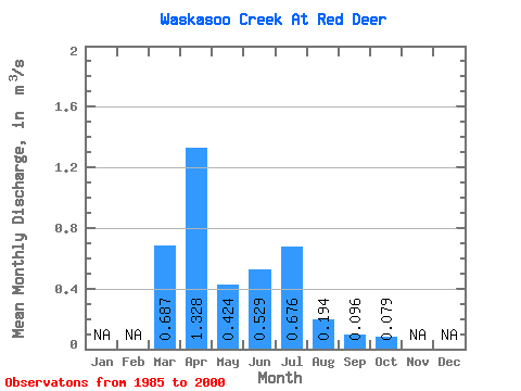
| Statistic | Jan | Feb | Mar | Apr | May | Jun | Jul | Aug | Sep | Oct | Nov | Dec | Annual |
|---|---|---|---|---|---|---|---|---|---|---|---|---|---|
| Mean | 0.69 | 1.33 | 0.42 | 0.53 | 0.68 | 0.19 | 0.10 | 0.08 | |||||
| Standard Deviation | 0.54 | 1.68 | 0.51 | 1.17 | 1.31 | 0.22 | 0.12 | 0.15 | |||||
| Min | 0.06 | 0.06 | 0.02 | 0.02 | 0.03 | 0.02 | 0.02 | 0.02 | |||||
| Max | 1.88 | 5.85 | 2.04 | 4.84 | 5.28 | 0.82 | 0.51 | 0.64 | |||||
| Coefficient of Variation | 0.78 | 1.26 | 1.21 | 2.21 | 1.93 | 1.12 | 1.28 | 1.92 |
 Return to R-Arctic Net Home Page