|
|
|||||||||||||||||
| Point ID: 379 | Downloads | Plots | Site Data | Code: 05CC011 |
|
|
|||||||||||||||||
| Download | |
|---|---|
| Site Descriptor Information | Site Time Series Data |
| Link to all available data | |
| View: | Time Series | All |
| Units: | m3/s |
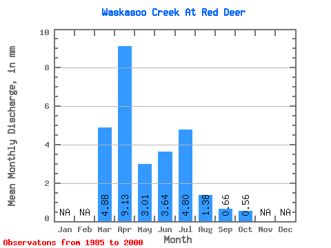
| Statistic | Jan | Feb | Mar | Apr | May | Jun | Jul | Aug | Sep | Oct | Nov | Dec | Annual |
|---|---|---|---|---|---|---|---|---|---|---|---|---|---|
| Mean | 3.72 | 6.97 | 2.30 | 2.78 | 3.67 | 1.05 | 0.51 | 0.43 | |||||
| Standard Deviation | 2.92 | 8.80 | 2.78 | 6.12 | 7.09 | 1.18 | 0.64 | 0.82 | |||||
| Min | 0.34 | 0.33 | 0.11 | 0.11 | 0.14 | 0.10 | 0.09 | 0.09 | |||||
| Max | 10.19 | 30.70 | 11.06 | 25.39 | 28.62 | 4.43 | 2.68 | 3.46 | |||||
| Coefficient of Variation | 0.78 | 1.26 | 1.21 | 2.21 | 1.93 | 1.12 | 1.28 | 1.92 |
 Return to R-Arctic Net Home Page