|
|
|||||||||||||||||
| Point ID: 3694 | Downloads | Plots | Site Data | Code: 10UH001 |
|
|
|||||||||||||||||
| Download | |
|---|---|
| Site Descriptor Information | Site Time Series Data |
| Link to all available data | |
| View: | Time Series | All |
| Units: | mm |
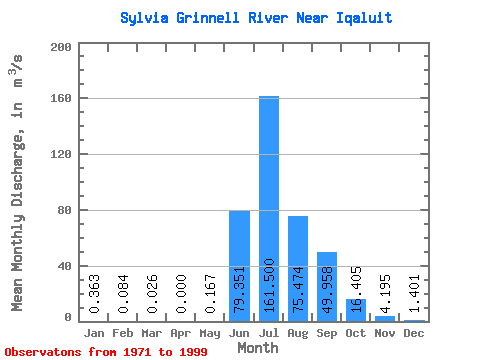
| Statistic | Jan | Feb | Mar | Apr | May | Jun | Jul | Aug | Sep | Oct | Nov | Dec | Annual |
|---|---|---|---|---|---|---|---|---|---|---|---|---|---|
| Mean | 0.36 | 0.08 | 0.03 | 0.00 | 0.17 | 79.35 | 161.50 | 75.47 | 49.96 | 16.41 | 4.20 | 1.40 | 30.18 |
| Standard Deviation | 0.36 | 0.24 | 0.08 | 0.00 | 0.48 | 46.11 | 74.27 | 23.48 | 22.59 | 5.29 | 1.83 | 0.74 | 4.34 |
| Min | 0.00 | 0.00 | 0.00 | 0.00 | 0.00 | 4.40 | 64.60 | 28.70 | 19.00 | 9.99 | 2.01 | 0.38 | 26.48 |
| Max | 1.26 | 0.76 | 0.26 | 0.00 | 1.52 | 148.00 | 342.00 | 123.00 | 130.00 | 26.70 | 7.96 | 2.74 | 36.66 |
| Coefficient of Variation | 0.98 | 2.84 | 3.16 | 2.86 | 0.58 | 0.46 | 0.31 | 0.45 | 0.32 | 0.44 | 0.53 | 0.14 |
 Return to R-Arctic Net Home Page