|
|
|||||||||||||||||
| Point ID: 3694 | Downloads | Plots | Site Data | Code: 10UH001 |
|
|
|||||||||||||||||
| Download | |
|---|---|
| Site Descriptor Information | Site Time Series Data |
| Link to all available data | |
| View: | Time Series | All |
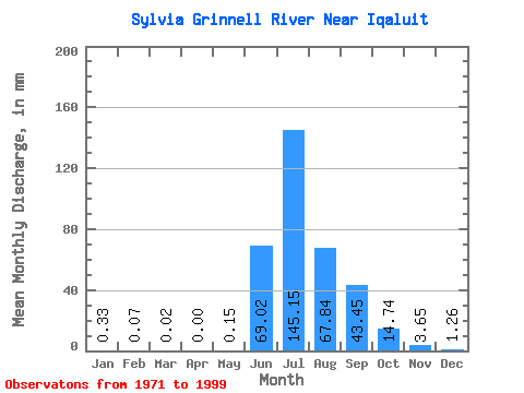
| Units: | m3/s |
| Statistic | Jan | Feb | Mar | Apr | May | Jun | Jul | Aug | Sep | Oct | Nov | Dec | Annual |
|---|---|---|---|---|---|---|---|---|---|---|---|---|---|
| Mean | 0.33 | 0.07 | 0.02 | 0.00 | 0.15 | 69.02 | 145.13 | 67.83 | 43.45 | 14.74 | 3.65 | 1.26 | 319.61 |
| Standard Deviation | 0.32 | 0.19 | 0.07 | 0.00 | 0.43 | 40.11 | 66.74 | 21.10 | 19.65 | 4.76 | 1.59 | 0.66 | 45.93 |
| Min | 0.00 | 0.00 | 0.00 | 0.00 | 0.00 | 3.83 | 58.05 | 25.79 | 16.53 | 8.98 | 1.75 | 0.34 | 280.45 |
| Max | 1.13 | 0.62 | 0.23 | 0.00 | 1.37 | 128.73 | 307.34 | 110.53 | 113.07 | 23.99 | 6.92 | 2.46 | 388.21 |
| Coefficient of Variation | 0.98 | 2.84 | 3.16 | 2.86 | 0.58 | 0.46 | 0.31 | 0.45 | 0.32 | 0.44 | 0.53 | 0.14 |
 Return to R-Arctic Net Home Page