|
|
|||||||||||||||||
| Point ID: 3688 | Downloads | Plots | Site Data | Code: 10TA001 |
|
|
|||||||||||||||||
| Download | |
|---|---|
| Site Descriptor Information | Site Time Series Data |
| Link to all available data | |
| View: | Time Series | All |
| Units: | mm |
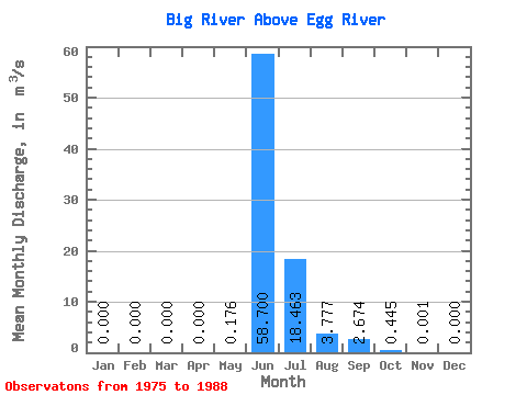
| Statistic | Jan | Feb | Mar | Apr | May | Jun | Jul | Aug | Sep | Oct | Nov | Dec | Annual |
|---|---|---|---|---|---|---|---|---|---|---|---|---|---|
| Mean | 0.00 | 0.00 | 0.00 | 0.00 | 0.18 | 58.70 | 18.46 | 3.78 | 2.67 | 0.45 | 0.00 | 0.00 | 7.21 |
| Standard Deviation | 0.00 | 0.00 | 0.00 | 0.00 | 0.40 | 30.53 | 11.70 | 2.71 | 5.12 | 1.25 | 0.01 | 0.00 | 2.19 |
| Min | 0.00 | 0.00 | 0.00 | 0.00 | 0.00 | 4.90 | 5.44 | 1.31 | 0.00 | 0.00 | 0.00 | 0.00 | 3.95 |
| Max | 0.00 | 0.00 | 0.00 | 0.00 | 1.10 | 94.00 | 40.10 | 8.65 | 18.60 | 4.37 | 0.02 | 0.00 | 10.59 |
| Coefficient of Variation | 2.25 | 0.52 | 0.63 | 0.72 | 1.91 | 2.80 | 3.25 | 0.30 |
 Return to R-Arctic Net Home Page