|
|
|||||||||||||||||
| Point ID: 3688 | Downloads | Plots | Site Data | Code: 10TA001 |
|
|
|||||||||||||||||
| Download | |
|---|---|
| Site Descriptor Information | Site Time Series Data |
| Link to all available data | |
| View: | Time Series | All |
| Units: | m3/s |
| Statistic | Jan | Feb | Mar | Apr | May | Jun | Jul | Aug | Sep | Oct | Nov | Dec | Annual |
|---|---|---|---|---|---|---|---|---|---|---|---|---|---|
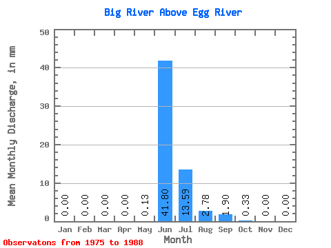
| Mean | 0.00 | 0.00 | 0.00 | 0.00 | 0.13 | 41.80 | 13.58 | 2.78 | 1.90 | 0.33 | 0.00 | 0.00 | 62.51 |
| Standard Deviation | 0.00 | 0.00 | 0.00 | 0.00 | 0.29 | 21.74 | 8.61 | 2.00 | 3.64 | 0.92 | 0.00 | 0.00 | 19.01 |
| Min | 0.00 | 0.00 | 0.00 | 0.00 | 0.00 | 3.49 | 4.00 | 0.96 | 0.00 | 0.00 | 0.00 | 0.00 | 34.25 |
| Max | 0.00 | 0.00 | 0.00 | 0.00 | 0.81 | 66.94 | 29.50 | 6.36 | 13.24 | 3.21 | 0.01 | 0.00 | 91.83 |
| Coefficient of Variation | 2.25 | 0.52 | 0.63 | 0.72 | 1.91 | 2.80 | 3.25 | 0.30 |
 Return to R-Arctic Net Home Page