|
|
|||||||||||||||||
| Point ID: 3672 | Downloads | Plots | Site Data | Code: 10ND004 |
|
|
|||||||||||||||||
| Download | |
|---|---|
| Site Descriptor Information | Site Time Series Data |
| Link to all available data | |
| View: | Time Series | All |
| Units: | mm |
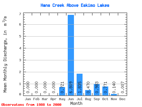
| Statistic | Jan | Feb | Mar | Apr | May | Jun | Jul | Aug | Sep | Oct | Nov | Dec | Annual |
|---|---|---|---|---|---|---|---|---|---|---|---|---|---|
| Mean | 0.00 | 0.00 | 0.00 | 0.00 | 0.72 | 6.81 | 1.83 | 0.47 | 0.98 | 0.77 | 0.14 | 0.01 | 0.94 |
| Standard Deviation | 0.00 | 0.00 | 0.00 | 0.00 | 1.38 | 2.18 | 0.61 | 0.36 | 0.87 | 0.57 | 0.14 | 0.02 | 0.14 |
| Min | 0.00 | 0.00 | 0.00 | 0.00 | 0.00 | 3.55 | 0.99 | 0.17 | 0.00 | 0.00 | 0.00 | 0.00 | 0.79 |
| Max | 0.00 | 0.00 | 0.00 | 0.00 | 4.27 | 10.60 | 2.83 | 1.10 | 2.57 | 1.56 | 0.39 | 0.06 | 1.12 |
| Coefficient of Variation | 3.16 | 1.91 | 0.32 | 0.33 | 0.77 | 0.89 | 0.73 | 0.98 | 2.46 | 0.15 |
 Return to R-Arctic Net Home Page