|
|
|||||||||||||||||
| Point ID: 3672 | Downloads | Plots | Site Data | Code: 10ND004 |
|
|
|||||||||||||||||
| Download | |
|---|---|
| Site Descriptor Information | Site Time Series Data |
| Link to all available data | |
| View: | Time Series | All |
| Units: | m3/s |
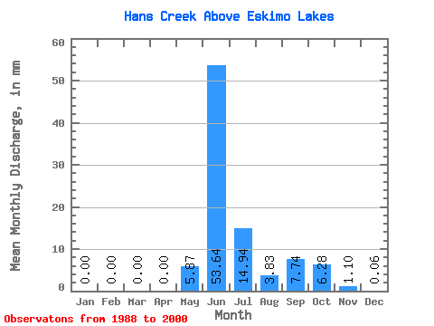
| Statistic | Jan | Feb | Mar | Apr | May | Jun | Jul | Aug | Sep | Oct | Nov | Dec | Annual |
|---|---|---|---|---|---|---|---|---|---|---|---|---|---|
| Mean | 0.00 | 0.00 | 0.00 | 0.00 | 5.87 | 53.65 | 14.94 | 3.82 | 7.75 | 6.27 | 1.11 | 0.06 | 90.34 |
| Standard Deviation | 0.01 | 0.00 | 0.00 | 0.00 | 11.20 | 17.15 | 4.96 | 2.96 | 6.87 | 4.61 | 1.09 | 0.14 | 13.53 |
| Min | 0.00 | 0.00 | 0.00 | 0.00 | 0.00 | 27.97 | 8.09 | 1.35 | 0.03 | 0.00 | 0.00 | 0.00 | 75.70 |
| Max | 0.02 | 0.00 | 0.00 | 0.00 | 34.76 | 83.51 | 23.04 | 8.95 | 20.25 | 12.70 | 3.06 | 0.48 | 107.10 |
| Coefficient of Variation | 3.16 | 1.91 | 0.32 | 0.33 | 0.77 | 0.89 | 0.73 | 0.98 | 2.46 | 0.15 |
 Return to R-Arctic Net Home Page