|
|
|||||||||||||||||
| Point ID: 3651 | Downloads | Plots | Site Data | Code: 10LA004 |
|
|
|||||||||||||||||
| Download | |
|---|---|
| Site Descriptor Information | Site Time Series Data |
| Link to all available data | |
| View: | Time Series | All |
| Units: | mm |
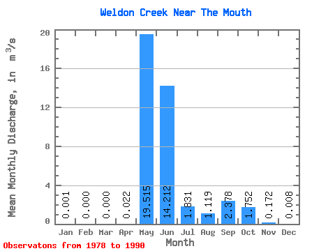
| Statistic | Jan | Feb | Mar | Apr | May | Jun | Jul | Aug | Sep | Oct | Nov | Dec | Annual |
|---|---|---|---|---|---|---|---|---|---|---|---|---|---|
| Mean | 0.00 | 0.00 | 0.00 | 0.02 | 19.52 | 14.21 | 1.83 | 1.12 | 2.38 | 1.75 | 0.17 | 0.01 | 3.42 |
| Standard Deviation | 0.00 | 0.00 | 0.00 | 0.07 | 8.68 | 8.88 | 1.90 | 1.36 | 2.13 | 1.78 | 0.20 | 0.02 | 0.72 |
| Min | 0.00 | 0.00 | 0.00 | 0.00 | 2.14 | 3.62 | 0.21 | 0.10 | 0.24 | 0.21 | 0.00 | 0.00 | 2.37 |
| Max | 0.01 | 0.01 | 0.00 | 0.27 | 30.30 | 33.20 | 7.48 | 5.04 | 7.11 | 6.71 | 0.51 | 0.06 | 4.79 |
| Coefficient of Variation | 3.61 | 3.61 | 3.27 | 0.45 | 0.62 | 1.04 | 1.22 | 0.90 | 1.01 | 1.15 | 2.27 | 0.21 |
 Return to R-Arctic Net Home Page