|
|
|||||||||||||||||
| Point ID: 3651 | Downloads | Plots | Site Data | Code: 10LA004 |
|
|
|||||||||||||||||
| Download | |
|---|---|
| Site Descriptor Information | Site Time Series Data |
| Link to all available data | |
| View: | Time Series | All |
| Units: | m3/s |
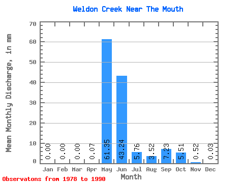
| Statistic | Jan | Feb | Mar | Apr | May | Jun | Jul | Aug | Sep | Oct | Nov | Dec | Annual |
|---|---|---|---|---|---|---|---|---|---|---|---|---|---|
| Mean | 0.00 | 0.00 | 0.00 | 0.07 | 61.34 | 43.23 | 5.75 | 3.52 | 7.23 | 5.51 | 0.52 | 0.02 | 126.59 |
| Standard Deviation | 0.01 | 0.00 | 0.00 | 0.22 | 27.28 | 27.00 | 5.98 | 4.29 | 6.50 | 5.59 | 0.60 | 0.05 | 26.60 |
| Min | 0.00 | 0.00 | 0.00 | 0.00 | 6.73 | 11.01 | 0.66 | 0.32 | 0.72 | 0.65 | 0.00 | 0.00 | 87.69 |
| Max | 0.04 | 0.01 | 0.00 | 0.81 | 95.24 | 101.00 | 23.51 | 15.84 | 21.63 | 21.09 | 1.55 | 0.17 | 177.36 |
| Coefficient of Variation | 3.61 | 3.61 | 3.27 | 0.45 | 0.62 | 1.04 | 1.22 | 0.90 | 1.01 | 1.15 | 2.27 | 0.21 |
 Return to R-Arctic Net Home Page