|
|
|||||||||||||||||
| Point ID: 3642 | Downloads | Plots | Site Data | Code: 10KA001 |
|
|
|||||||||||||||||
| Download | |
|---|---|
| Site Descriptor Information | Site Time Series Data |
| Link to all available data | |
| View: | Time Series | All |
| Units: | mm |
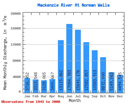
| Statistic | Jan | Feb | Mar | Apr | May | Jun | Jul | Aug | Sep | Oct | Nov | Dec | Annual |
|---|---|---|---|---|---|---|---|---|---|---|---|---|---|
| Mean | 3716.45 | 3313.55 | 3128.07 | 3400.67 | 13115.86 | 17084.78 | 15641.18 | 12582.86 | 10583.91 | 8872.00 | 5149.06 | 4494.55 | 8445.80 |
| Standard Deviation | 1052.55 | 669.00 | 587.86 | 599.25 | 2910.86 | 3059.70 | 3084.89 | 2154.21 | 1574.33 | 1285.52 | 1772.00 | 2889.75 | 894.29 |
| Min | 2260.00 | 2130.00 | 2190.00 | 2430.00 | 6680.00 | 10000.00 | 8540.00 | 6920.00 | 6590.00 | 6270.00 | 2340.00 | 2250.00 | 5965.00 |
| Max | 6680.00 | 4960.00 | 4670.00 | 4920.00 | 18600.00 | 24400.00 | 24700.00 | 18100.00 | 13700.00 | 13400.00 | 10000.00 | 18100.00 | 9910.00 |
| Coefficient of Variation | 0.28 | 0.20 | 0.19 | 0.18 | 0.22 | 0.18 | 0.20 | 0.17 | 0.15 | 0.14 | 0.34 | 0.64 | 0.11 |
 Return to R-Arctic Net Home Page