|
|
|||||||||||||||||
| Point ID: 3642 | Downloads | Plots | Site Data | Code: 10KA001 |
|
|
|||||||||||||||||
| Download | |
|---|---|
| Site Descriptor Information | Site Time Series Data |
| Link to all available data | |
| View: | Time Series | All |
| Units: | m3/s |
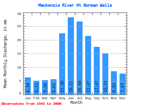
| Statistic | Jan | Feb | Mar | Apr | May | Jun | Jul | Aug | Sep | Oct | Nov | Dec | Annual |
|---|---|---|---|---|---|---|---|---|---|---|---|---|---|
| Mean | 6.34 | 5.15 | 5.34 | 5.61 | 22.37 | 28.21 | 26.68 | 21.46 | 17.47 | 15.13 | 8.50 | 7.67 | 169.78 |
| Standard Deviation | 1.79 | 1.04 | 1.00 | 0.99 | 4.96 | 5.05 | 5.26 | 3.67 | 2.60 | 2.19 | 2.92 | 4.93 | 17.98 |
| Min | 3.85 | 3.31 | 3.74 | 4.01 | 11.39 | 16.51 | 14.57 | 11.80 | 10.88 | 10.70 | 3.86 | 3.84 | 119.91 |
| Max | 11.39 | 7.71 | 7.97 | 8.12 | 31.73 | 40.28 | 42.13 | 30.87 | 22.62 | 22.86 | 16.51 | 30.87 | 199.21 |
| Coefficient of Variation | 0.28 | 0.20 | 0.19 | 0.18 | 0.22 | 0.18 | 0.20 | 0.17 | 0.15 | 0.14 | 0.34 | 0.64 | 0.11 |
 Return to R-Arctic Net Home Page