|
|
|||||||||||||||||
| Point ID: 3641 | Downloads | Plots | Site Data | Code: 10JE001 |
|
|
|||||||||||||||||
| Download | |
|---|---|
| Site Descriptor Information | Site Time Series Data |
| Link to all available data | |
| View: | Time Series | All |
| Units: | mm |
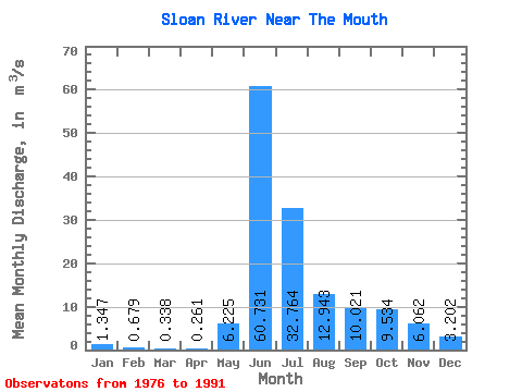
| Statistic | Jan | Feb | Mar | Apr | May | Jun | Jul | Aug | Sep | Oct | Nov | Dec | Annual |
|---|---|---|---|---|---|---|---|---|---|---|---|---|---|
| Mean | 1.35 | 0.68 | 0.34 | 0.26 | 6.22 | 60.73 | 32.76 | 12.94 | 10.02 | 9.53 | 6.06 | 3.20 | 12.32 |
| Standard Deviation | 1.15 | 0.88 | 0.49 | 0.36 | 6.79 | 26.80 | 13.41 | 3.80 | 6.62 | 8.35 | 4.66 | 2.37 | 4.53 |
| Min | 0.08 | 0.00 | 0.00 | 0.00 | 0.06 | 17.10 | 17.50 | 8.73 | 4.65 | 2.87 | 1.29 | 0.75 | 6.88 |
| Max | 3.92 | 2.63 | 1.60 | 1.11 | 24.70 | 101.00 | 62.50 | 21.40 | 30.40 | 31.10 | 16.40 | 8.59 | 22.85 |
| Coefficient of Variation | 0.85 | 1.30 | 1.45 | 1.38 | 1.09 | 0.44 | 0.41 | 0.29 | 0.66 | 0.88 | 0.77 | 0.74 | 0.37 |
 Return to R-Arctic Net Home Page