|
|
|||||||||||||||||
| Point ID: 3641 | Downloads | Plots | Site Data | Code: 10JE001 |
|
|
|||||||||||||||||
| Download | |
|---|---|
| Site Descriptor Information | Site Time Series Data |
| Link to all available data | |
| View: | Time Series | All |
| Units: | m3/s |
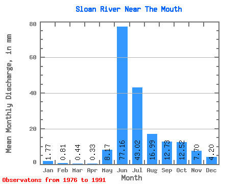
| Statistic | Jan | Feb | Mar | Apr | May | Jun | Jul | Aug | Sep | Oct | Nov | Dec | Annual |
|---|---|---|---|---|---|---|---|---|---|---|---|---|---|
| Mean | 1.77 | 0.81 | 0.44 | 0.33 | 8.17 | 77.16 | 43.01 | 16.99 | 12.73 | 12.52 | 7.70 | 4.20 | 190.66 |
| Standard Deviation | 1.51 | 1.06 | 0.64 | 0.46 | 8.92 | 34.06 | 17.60 | 4.99 | 8.41 | 10.97 | 5.92 | 3.12 | 70.09 |
| Min | 0.11 | 0.00 | 0.00 | 0.00 | 0.07 | 21.73 | 22.97 | 11.46 | 5.91 | 3.77 | 1.64 | 0.98 | 106.38 |
| Max | 5.15 | 3.15 | 2.10 | 1.41 | 32.42 | 128.33 | 82.05 | 28.09 | 38.63 | 40.83 | 20.84 | 11.28 | 353.46 |
| Coefficient of Variation | 0.85 | 1.30 | 1.45 | 1.38 | 1.09 | 0.44 | 0.41 | 0.29 | 0.66 | 0.88 | 0.77 | 0.74 | 0.37 |
 Return to R-Arctic Net Home Page