|
|
|||||||||||||||||
| Point ID: 3630 | Downloads | Plots | Site Data | Code: 10HB004 |
|
|
|||||||||||||||||
| Download | |
|---|---|
| Site Descriptor Information | Site Time Series Data |
| Link to all available data | |
| View: | Time Series | All |
| Units: | mm |
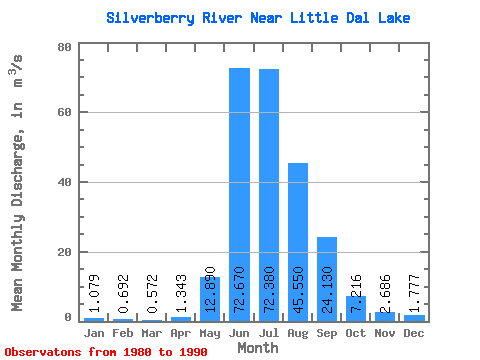
| Statistic | Jan | Feb | Mar | Apr | May | Jun | Jul | Aug | Sep | Oct | Nov | Dec | Annual |
|---|---|---|---|---|---|---|---|---|---|---|---|---|---|
| Mean | 1.08 | 0.69 | 0.57 | 1.34 | 12.89 | 72.67 | 72.38 | 45.55 | 24.13 | 7.22 | 2.69 | 1.78 | 20.29 |
| Standard Deviation | 0.63 | 0.54 | 0.46 | 0.92 | 6.90 | 16.06 | 19.91 | 14.52 | 12.24 | 3.73 | 1.09 | 0.76 | 2.68 |
| Min | 0.25 | 0.15 | 0.07 | 0.52 | 6.25 | 52.50 | 47.40 | 24.10 | 13.60 | 3.53 | 0.76 | 0.37 | 15.28 |
| Max | 2.45 | 2.06 | 1.74 | 3.38 | 29.30 | 98.20 | 101.00 | 70.20 | 46.10 | 16.90 | 4.82 | 2.82 | 25.17 |
| Coefficient of Variation | 0.58 | 0.78 | 0.80 | 0.69 | 0.54 | 0.22 | 0.28 | 0.32 | 0.51 | 0.52 | 0.41 | 0.43 | 0.13 |
 Return to R-Arctic Net Home Page