|
|
|||||||||||||||||
| Point ID: 3630 | Downloads | Plots | Site Data | Code: 10HB004 |
|
|
|||||||||||||||||
| Download | |
|---|---|
| Site Descriptor Information | Site Time Series Data |
| Link to all available data | |
| View: | Time Series | All |
| Units: | m3/s |
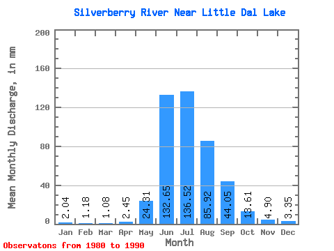
| Statistic | Jan | Feb | Mar | Apr | May | Jun | Jul | Aug | Sep | Oct | Nov | Dec | Annual |
|---|---|---|---|---|---|---|---|---|---|---|---|---|---|
| Mean | 2.04 | 1.19 | 1.08 | 2.45 | 24.31 | 132.65 | 136.50 | 85.90 | 44.05 | 13.61 | 4.90 | 3.35 | 450.86 |
| Standard Deviation | 1.19 | 0.93 | 0.86 | 1.69 | 13.01 | 29.31 | 37.55 | 27.38 | 22.35 | 7.04 | 1.99 | 1.44 | 59.61 |
| Min | 0.47 | 0.25 | 0.14 | 0.95 | 11.79 | 95.83 | 89.39 | 45.45 | 24.82 | 6.66 | 1.39 | 0.70 | 339.50 |
| Max | 4.62 | 3.54 | 3.28 | 6.17 | 55.26 | 179.25 | 190.48 | 132.39 | 84.15 | 31.87 | 8.80 | 5.32 | 559.33 |
| Coefficient of Variation | 0.58 | 0.78 | 0.80 | 0.69 | 0.54 | 0.22 | 0.28 | 0.32 | 0.51 | 0.52 | 0.41 | 0.43 | 0.13 |
 Return to R-Arctic Net Home Page