|
|
|||||||||||||||||
| Point ID: 3624 | Downloads | Plots | Site Data | Code: 10GC003 |
|
|
|||||||||||||||||
| Download | |
|---|---|
| Site Descriptor Information | Site Time Series Data |
| Link to all available data | |
| View: | Time Series | All |
| Units: | mm |
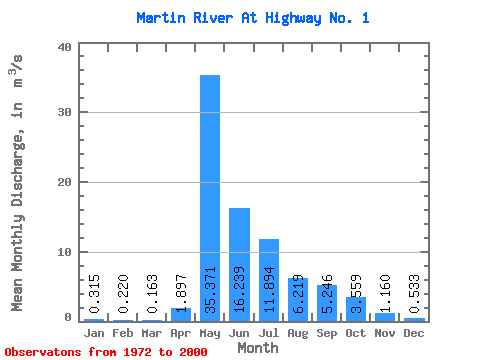
| Statistic | Jan | Feb | Mar | Apr | May | Jun | Jul | Aug | Sep | Oct | Nov | Dec | Annual |
|---|---|---|---|---|---|---|---|---|---|---|---|---|---|
| Mean | 0.32 | 0.22 | 0.16 | 1.90 | 35.37 | 16.24 | 11.89 | 6.22 | 5.25 | 3.56 | 1.16 | 0.53 | 6.91 |
| Standard Deviation | 0.29 | 0.21 | 0.14 | 2.85 | 20.02 | 11.70 | 20.44 | 5.92 | 5.63 | 3.00 | 1.06 | 0.47 | 3.96 |
| Min | 0.00 | 0.00 | 0.00 | 0.00 | 5.13 | 0.93 | 0.11 | 0.12 | 0.12 | 0.16 | 0.10 | 0.03 | 1.58 |
| Max | 1.24 | 0.94 | 0.58 | 14.30 | 94.10 | 46.70 | 112.00 | 24.00 | 20.00 | 11.80 | 4.17 | 1.82 | 19.33 |
| Coefficient of Variation | 0.93 | 0.97 | 0.89 | 1.50 | 0.57 | 0.72 | 1.72 | 0.95 | 1.07 | 0.84 | 0.92 | 0.88 | 0.57 |
 Return to R-Arctic Net Home Page