|
|
|||||||||||||||||
| Point ID: 3624 | Downloads | Plots | Site Data | Code: 10GC003 |
|
|
|||||||||||||||||
| Download | |
|---|---|
| Site Descriptor Information | Site Time Series Data |
| Link to all available data | |
| View: | Time Series | All |
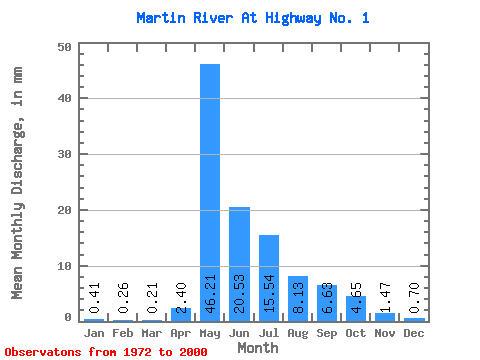
| Units: | m3/s |
| Statistic | Jan | Feb | Mar | Apr | May | Jun | Jul | Aug | Sep | Oct | Nov | Dec | Annual |
|---|---|---|---|---|---|---|---|---|---|---|---|---|---|
| Mean | 0.41 | 0.26 | 0.21 | 2.40 | 46.21 | 20.53 | 15.54 | 8.12 | 6.63 | 4.65 | 1.47 | 0.70 | 106.40 |
| Standard Deviation | 0.38 | 0.25 | 0.19 | 3.60 | 26.16 | 14.79 | 26.70 | 7.73 | 7.12 | 3.92 | 1.35 | 0.62 | 60.96 |
| Min | 0.00 | 0.00 | 0.00 | 0.01 | 6.70 | 1.18 | 0.14 | 0.16 | 0.16 | 0.20 | 0.12 | 0.04 | 24.28 |
| Max | 1.62 | 1.12 | 0.76 | 18.08 | 122.93 | 59.05 | 146.31 | 31.35 | 25.29 | 15.41 | 5.27 | 2.38 | 297.55 |
| Coefficient of Variation | 0.93 | 0.97 | 0.89 | 1.50 | 0.57 | 0.72 | 1.72 | 0.95 | 1.07 | 0.84 | 0.92 | 0.88 | 0.57 |
 Return to R-Arctic Net Home Page