|
|
|||||||||||||||||
| Point ID: 3606 | Downloads | Plots | Site Data | Code: 10ED003 |
|
|
|||||||||||||||||
| Download | |
|---|---|
| Site Descriptor Information | Site Time Series Data |
| Link to all available data | |
| View: | Time Series | All |
| Units: | mm |
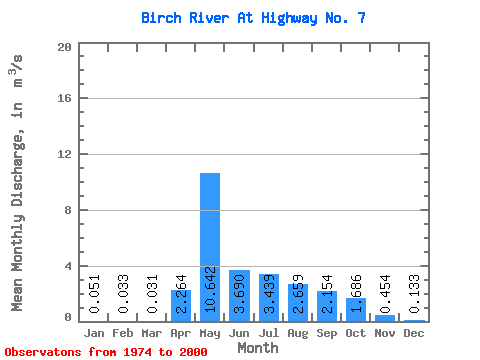
| Statistic | Jan | Feb | Mar | Apr | May | Jun | Jul | Aug | Sep | Oct | Nov | Dec | Annual |
|---|---|---|---|---|---|---|---|---|---|---|---|---|---|
| Mean | 0.05 | 0.03 | 0.03 | 2.26 | 10.64 | 3.69 | 3.44 | 2.66 | 2.15 | 1.69 | 0.45 | 0.13 | 2.33 |
| Standard Deviation | 0.05 | 0.03 | 0.04 | 2.24 | 6.82 | 3.22 | 6.50 | 3.07 | 2.52 | 1.41 | 0.43 | 0.10 | 1.09 |
| Min | 0.00 | 0.00 | 0.00 | 0.01 | 1.15 | 0.13 | 0.04 | 0.01 | 0.03 | 0.05 | 0.02 | 0.00 | 0.45 |
| Max | 0.22 | 0.15 | 0.15 | 8.92 | 24.30 | 12.40 | 33.80 | 11.40 | 10.40 | 5.72 | 2.00 | 0.35 | 5.72 |
| Coefficient of Variation | 0.90 | 1.03 | 1.18 | 0.99 | 0.64 | 0.87 | 1.89 | 1.16 | 1.17 | 0.84 | 0.94 | 0.72 | 0.47 |
 Return to R-Arctic Net Home Page