|
|
|||||||||||||||||
| Point ID: 3606 | Downloads | Plots | Site Data | Code: 10ED003 |
|
|
|||||||||||||||||
| Download | |
|---|---|
| Site Descriptor Information | Site Time Series Data |
| Link to all available data | |
| View: | Time Series | All |
| Units: | m3/s |
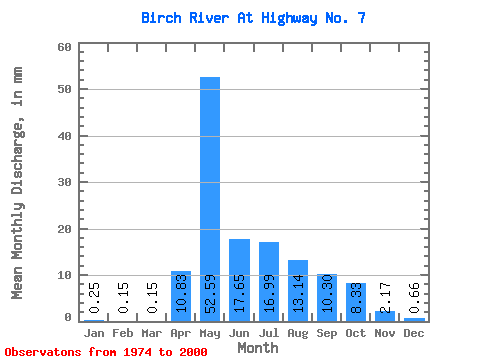
| Statistic | Jan | Feb | Mar | Apr | May | Jun | Jul | Aug | Sep | Oct | Nov | Dec | Annual |
|---|---|---|---|---|---|---|---|---|---|---|---|---|---|
| Mean | 0.25 | 0.15 | 0.15 | 10.83 | 52.58 | 17.65 | 16.99 | 13.14 | 10.30 | 8.33 | 2.17 | 0.66 | 135.78 |
| Standard Deviation | 0.23 | 0.15 | 0.18 | 10.69 | 33.69 | 15.40 | 32.10 | 15.17 | 12.07 | 6.98 | 2.04 | 0.47 | 63.68 |
| Min | 0.00 | 0.00 | 0.00 | 0.05 | 5.68 | 0.61 | 0.18 | 0.06 | 0.15 | 0.24 | 0.10 | 0.01 | 26.32 |
| Max | 1.09 | 0.68 | 0.74 | 42.66 | 120.06 | 59.30 | 167.00 | 56.33 | 49.74 | 28.26 | 9.56 | 1.75 | 332.84 |
| Coefficient of Variation | 0.90 | 1.03 | 1.18 | 0.99 | 0.64 | 0.87 | 1.89 | 1.16 | 1.17 | 0.84 | 0.94 | 0.72 | 0.47 |
 Return to R-Arctic Net Home Page