|
|
|||||||||||||||||
| Point ID: 3601 | Downloads | Plots | Site Data | Code: 10EB003 |
|
|
|||||||||||||||||
| Download | |
|---|---|
| Site Descriptor Information | Site Time Series Data |
| Link to all available data | |
| View: | Time Series | All |
| Units: | mm |
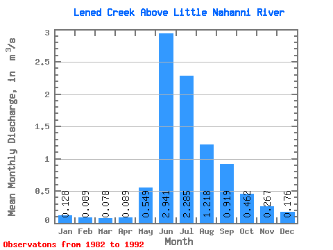
| Statistic | Jan | Feb | Mar | Apr | May | Jun | Jul | Aug | Sep | Oct | Nov | Dec | Annual |
|---|---|---|---|---|---|---|---|---|---|---|---|---|---|
| Mean | 0.13 | 0.09 | 0.08 | 0.09 | 0.55 | 2.94 | 2.29 | 1.22 | 0.92 | 0.46 | 0.27 | 0.18 | 0.77 |
| Standard Deviation | 0.03 | 0.03 | 0.02 | 0.02 | 0.26 | 0.51 | 0.79 | 0.37 | 0.42 | 0.15 | 0.10 | 0.04 | 0.09 |
| Min | 0.08 | 0.05 | 0.04 | 0.06 | 0.21 | 2.19 | 1.05 | 0.57 | 0.34 | 0.26 | 0.15 | 0.11 | 0.60 |
| Max | 0.18 | 0.15 | 0.12 | 0.11 | 0.99 | 3.92 | 3.54 | 1.86 | 1.93 | 0.69 | 0.50 | 0.23 | 0.90 |
| Coefficient of Variation | 0.27 | 0.32 | 0.31 | 0.21 | 0.47 | 0.17 | 0.34 | 0.30 | 0.46 | 0.33 | 0.36 | 0.21 | 0.12 |
 Return to R-Arctic Net Home Page