|
|
|||||||||||||||||
| Point ID: 3601 | Downloads | Plots | Site Data | Code: 10EB003 |
|
|
|||||||||||||||||
| Download | |
|---|---|
| Site Descriptor Information | Site Time Series Data |
| Link to all available data | |
| View: | Time Series | All |
| Units: | m3/s |
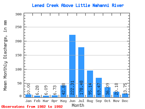
| Statistic | Jan | Feb | Mar | Apr | May | Jun | Jul | Aug | Sep | Oct | Nov | Dec | Annual |
|---|---|---|---|---|---|---|---|---|---|---|---|---|---|
| Mean | 9.97 | 6.35 | 6.09 | 6.76 | 42.86 | 222.31 | 178.46 | 95.14 | 69.48 | 36.11 | 20.15 | 13.73 | 709.70 |
| Standard Deviation | 2.67 | 2.04 | 1.91 | 1.40 | 20.25 | 38.76 | 61.28 | 28.71 | 32.09 | 11.88 | 7.17 | 2.95 | 81.27 |
| Min | 6.48 | 3.63 | 3.28 | 4.69 | 16.79 | 165.54 | 82.00 | 44.75 | 25.32 | 20.54 | 11.26 | 8.82 | 555.53 |
| Max | 14.37 | 10.53 | 9.22 | 8.47 | 77.00 | 296.31 | 276.47 | 145.26 | 145.89 | 53.58 | 38.10 | 17.65 | 823.75 |
| Coefficient of Variation | 0.27 | 0.32 | 0.31 | 0.21 | 0.47 | 0.17 | 0.34 | 0.30 | 0.46 | 0.33 | 0.36 | 0.21 | 0.12 |
 Return to R-Arctic Net Home Page