|
|
|||||||||||||||||
| Point ID: 3599 | Downloads | Plots | Site Data | Code: 10EB001 |
|
|
|||||||||||||||||
| Download | |
|---|---|
| Site Descriptor Information | Site Time Series Data |
| Link to all available data | |
| View: | Time Series | All |
| Units: | mm |
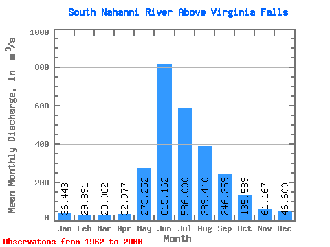
| Statistic | Jan | Feb | Mar | Apr | May | Jun | Jul | Aug | Sep | Oct | Nov | Dec | Annual |
|---|---|---|---|---|---|---|---|---|---|---|---|---|---|
| Mean | 36.44 | 29.89 | 28.06 | 32.98 | 273.25 | 815.16 | 586.00 | 389.41 | 246.36 | 135.59 | 61.17 | 46.60 | 224.78 |
| Standard Deviation | 7.70 | 6.55 | 5.37 | 6.61 | 122.83 | 174.44 | 138.87 | 67.21 | 72.22 | 34.08 | 10.59 | 9.13 | 22.20 |
| Min | 17.40 | 17.60 | 17.40 | 22.30 | 99.80 | 524.00 | 349.00 | 259.00 | 153.00 | 86.10 | 37.90 | 27.70 | 184.97 |
| Max | 53.40 | 40.90 | 40.00 | 51.60 | 552.00 | 1270.00 | 880.00 | 530.00 | 506.00 | 214.00 | 78.90 | 61.90 | 264.96 |
| Coefficient of Variation | 0.21 | 0.22 | 0.19 | 0.20 | 0.45 | 0.21 | 0.24 | 0.17 | 0.29 | 0.25 | 0.17 | 0.20 | 0.10 |
 Return to R-Arctic Net Home Page