|
|
|||||||||||||||||
| Point ID: 3599 | Downloads | Plots | Site Data | Code: 10EB001 |
|
|
|||||||||||||||||
| Download | |
|---|---|
| Site Descriptor Information | Site Time Series Data |
| Link to all available data | |
| View: | Time Series | All |
| Units: | m3/s |
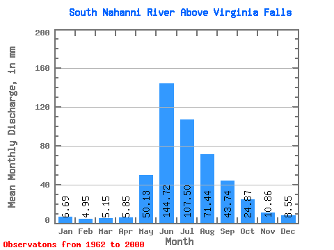
| Statistic | Jan | Feb | Mar | Apr | May | Jun | Jul | Aug | Sep | Oct | Nov | Dec | Annual |
|---|---|---|---|---|---|---|---|---|---|---|---|---|---|
| Mean | 6.69 | 5.00 | 5.15 | 5.86 | 50.12 | 144.72 | 107.49 | 71.43 | 43.74 | 24.87 | 10.86 | 8.55 | 485.89 |
| Standard Deviation | 1.41 | 1.09 | 0.99 | 1.17 | 22.53 | 30.97 | 25.47 | 12.33 | 12.82 | 6.25 | 1.88 | 1.68 | 47.99 |
| Min | 3.19 | 2.94 | 3.19 | 3.96 | 18.31 | 93.03 | 64.02 | 47.51 | 27.16 | 15.79 | 6.73 | 5.08 | 399.85 |
| Max | 9.79 | 6.83 | 7.34 | 9.16 | 101.25 | 225.47 | 161.41 | 97.22 | 89.83 | 39.25 | 14.01 | 11.35 | 572.75 |
| Coefficient of Variation | 0.21 | 0.22 | 0.19 | 0.20 | 0.45 | 0.21 | 0.24 | 0.17 | 0.29 | 0.25 | 0.17 | 0.20 | 0.10 |
 Return to R-Arctic Net Home Page