|
|
|||||||||||||||||
| Point ID: 3592 | Downloads | Plots | Site Data | Code: 07SC002 |
|
|
|||||||||||||||||
| Download | |
|---|---|
| Site Descriptor Information | Site Time Series Data |
| Link to all available data | |
| View: | Time Series | All |
| Units: | mm |
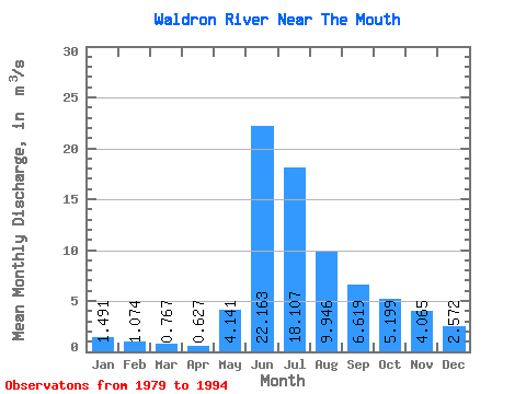
| Statistic | Jan | Feb | Mar | Apr | May | Jun | Jul | Aug | Sep | Oct | Nov | Dec | Annual |
|---|---|---|---|---|---|---|---|---|---|---|---|---|---|
| Mean | 1.49 | 1.07 | 0.77 | 0.63 | 4.14 | 22.16 | 18.11 | 9.95 | 6.62 | 5.20 | 4.07 | 2.57 | 6.40 |
| Standard Deviation | 0.51 | 0.36 | 0.22 | 0.18 | 5.00 | 16.66 | 8.13 | 4.55 | 4.33 | 3.80 | 3.00 | 1.75 | 2.81 |
| Min | 0.72 | 0.62 | 0.35 | 0.42 | 0.40 | 2.75 | 3.16 | 1.68 | 1.17 | 1.12 | 1.15 | 0.71 | 1.27 |
| Max | 2.40 | 1.93 | 1.27 | 0.99 | 19.00 | 63.20 | 31.00 | 20.70 | 18.20 | 15.10 | 12.10 | 6.45 | 12.39 |
| Coefficient of Variation | 0.34 | 0.34 | 0.29 | 0.29 | 1.21 | 0.75 | 0.45 | 0.46 | 0.66 | 0.73 | 0.74 | 0.68 | 0.44 |
 Return to R-Arctic Net Home Page