|
|
|||||||||||||||||
| Point ID: 3592 | Downloads | Plots | Site Data | Code: 07SC002 |
|
|
|||||||||||||||||
| Download | |
|---|---|
| Site Descriptor Information | Site Time Series Data |
| Link to all available data | |
| View: | Time Series | All |
| Units: | m3/s |
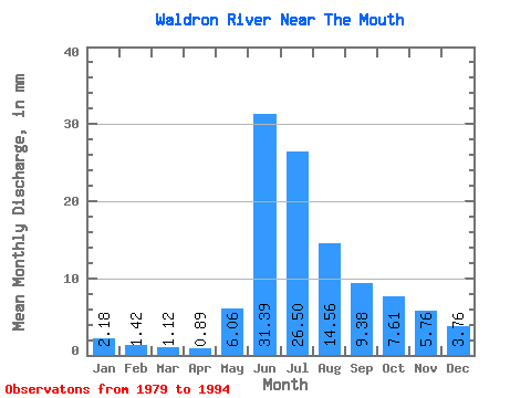
| Statistic | Jan | Feb | Mar | Apr | May | Jun | Jul | Aug | Sep | Oct | Nov | Dec | Annual |
|---|---|---|---|---|---|---|---|---|---|---|---|---|---|
| Mean | 2.18 | 1.43 | 1.12 | 0.89 | 6.06 | 31.39 | 26.50 | 14.55 | 9.38 | 7.61 | 5.76 | 3.76 | 110.33 |
| Standard Deviation | 0.74 | 0.48 | 0.32 | 0.26 | 7.31 | 23.59 | 11.89 | 6.66 | 6.14 | 5.56 | 4.25 | 2.56 | 48.37 |
| Min | 1.05 | 0.83 | 0.52 | 0.59 | 0.58 | 3.90 | 4.62 | 2.46 | 1.66 | 1.64 | 1.63 | 1.04 | 21.91 |
| Max | 3.51 | 2.57 | 1.86 | 1.41 | 27.80 | 89.52 | 45.37 | 30.29 | 25.78 | 22.10 | 17.14 | 9.44 | 213.75 |
| Coefficient of Variation | 0.34 | 0.34 | 0.29 | 0.29 | 1.21 | 0.75 | 0.45 | 0.46 | 0.66 | 0.73 | 0.74 | 0.68 | 0.44 |
 Return to R-Arctic Net Home Page