|
|
|||||||||||||||||
| Point ID: 3580 | Downloads | Plots | Site Data | Code: 07SA005 |
|
|
|||||||||||||||||
| Download | |
|---|---|
| Site Descriptor Information | Site Time Series Data |
| Link to all available data | |
| View: | Time Series | All |
| Units: | mm |
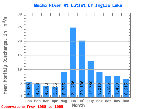
| Statistic | Jan | Feb | Mar | Apr | May | Jun | Jul | Aug | Sep | Oct | Nov | Dec | Annual |
|---|---|---|---|---|---|---|---|---|---|---|---|---|---|
| Mean | 5.49 | 4.67 | 4.09 | 3.66 | 8.94 | 24.74 | 20.14 | 12.98 | 9.01 | 7.66 | 7.43 | 6.62 | 9.69 |
| Standard Deviation | 1.70 | 1.30 | 1.03 | 0.92 | 6.23 | 12.85 | 7.85 | 5.99 | 4.60 | 3.63 | 3.28 | 2.44 | 3.40 |
| Min | 1.89 | 1.74 | 1.62 | 1.43 | 3.49 | 8.90 | 7.80 | 4.46 | 2.68 | 2.14 | 2.06 | 2.19 | 4.82 |
| Max | 7.98 | 6.58 | 5.54 | 5.20 | 24.80 | 41.00 | 31.20 | 23.40 | 17.00 | 13.80 | 12.30 | 9.88 | 15.35 |
| Coefficient of Variation | 0.31 | 0.28 | 0.25 | 0.25 | 0.70 | 0.52 | 0.39 | 0.46 | 0.51 | 0.47 | 0.44 | 0.37 | 0.35 |
 Return to R-Arctic Net Home Page