|
|
|||||||||||||||||
| Point ID: 3580 | Downloads | Plots | Site Data | Code: 07SA005 |
|
|
|||||||||||||||||
| Download | |
|---|---|
| Site Descriptor Information | Site Time Series Data |
| Link to all available data | |
| View: | Time Series | All |
| Units: | m3/s |
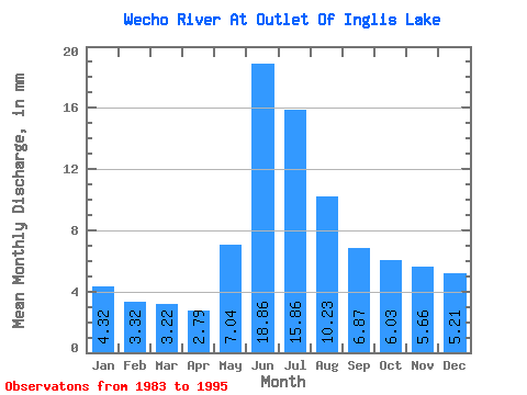
| Statistic | Jan | Feb | Mar | Apr | May | Jun | Jul | Aug | Sep | Oct | Nov | Dec | Annual |
|---|---|---|---|---|---|---|---|---|---|---|---|---|---|
| Mean | 4.32 | 3.35 | 3.22 | 2.79 | 7.04 | 18.86 | 15.86 | 10.22 | 6.87 | 6.03 | 5.66 | 5.21 | 89.96 |
| Standard Deviation | 1.34 | 0.93 | 0.81 | 0.70 | 4.91 | 9.80 | 6.18 | 4.72 | 3.51 | 2.86 | 2.50 | 1.92 | 31.60 |
| Min | 1.49 | 1.25 | 1.28 | 1.09 | 2.75 | 6.79 | 6.14 | 3.51 | 2.04 | 1.69 | 1.57 | 1.73 | 44.71 |
| Max | 6.29 | 4.72 | 4.36 | 3.96 | 19.53 | 31.26 | 24.57 | 18.43 | 12.96 | 10.87 | 9.38 | 7.78 | 142.47 |
| Coefficient of Variation | 0.31 | 0.28 | 0.25 | 0.25 | 0.70 | 0.52 | 0.39 | 0.46 | 0.51 | 0.47 | 0.44 | 0.37 | 0.35 |
 Return to R-Arctic Net Home Page