|
|
|||||||||||||||||
| Point ID: 3577 | Downloads | Plots | Site Data | Code: 07SA002 |
|
|
|||||||||||||||||
| Download | |
|---|---|
| Site Descriptor Information | Site Time Series Data |
| Link to all available data | |
| View: | Time Series | All |
| Units: | mm |
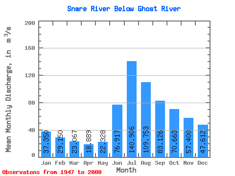
| Statistic | Jan | Feb | Mar | Apr | May | Jun | Jul | Aug | Sep | Oct | Nov | Dec | Annual |
|---|---|---|---|---|---|---|---|---|---|---|---|---|---|
| Mean | 37.35 | 29.15 | 23.07 | 18.89 | 22.33 | 76.92 | 140.91 | 109.75 | 83.13 | 70.66 | 57.40 | 47.61 | 56.92 |
| Standard Deviation | 13.03 | 8.79 | 6.14 | 4.91 | 5.51 | 47.96 | 55.40 | 29.44 | 26.36 | 38.33 | 25.23 | 18.97 | 15.08 |
| Min | 17.00 | 15.10 | 13.40 | 11.80 | 13.30 | 22.50 | 57.90 | 53.80 | 37.30 | 29.00 | 24.00 | 20.40 | 32.02 |
| Max | 71.80 | 50.30 | 36.30 | 29.60 | 32.90 | 191.00 | 244.00 | 169.00 | 157.00 | 217.00 | 147.00 | 102.00 | 94.88 |
| Coefficient of Variation | 0.35 | 0.30 | 0.27 | 0.26 | 0.25 | 0.62 | 0.39 | 0.27 | 0.32 | 0.54 | 0.44 | 0.40 | 0.27 |
 Return to R-Arctic Net Home Page