|
|
|||||||||||||||||
| Point ID: 3577 | Downloads | Plots | Site Data | Code: 07SA002 |
|
|
|||||||||||||||||
| Download | |
|---|---|
| Site Descriptor Information | Site Time Series Data |
| Link to all available data | |
| View: | Time Series | All |
| Units: | m3/s |
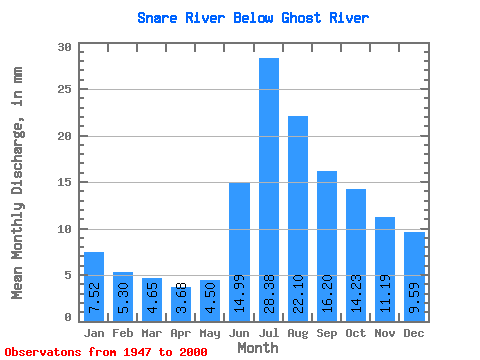
| Statistic | Jan | Feb | Mar | Apr | May | Jun | Jul | Aug | Sep | Oct | Nov | Dec | Annual |
|---|---|---|---|---|---|---|---|---|---|---|---|---|---|
| Mean | 7.52 | 5.35 | 4.64 | 3.68 | 4.50 | 14.99 | 28.37 | 22.10 | 16.20 | 14.23 | 11.19 | 9.59 | 135.06 |
| Standard Deviation | 2.62 | 1.61 | 1.24 | 0.96 | 1.11 | 9.35 | 11.15 | 5.93 | 5.14 | 7.72 | 4.92 | 3.82 | 35.79 |
| Min | 3.42 | 2.77 | 2.70 | 2.30 | 2.68 | 4.38 | 11.66 | 10.83 | 7.27 | 5.84 | 4.68 | 4.11 | 75.99 |
| Max | 14.46 | 9.23 | 7.31 | 5.77 | 6.62 | 37.22 | 49.13 | 34.03 | 30.60 | 43.69 | 28.65 | 20.54 | 225.15 |
| Coefficient of Variation | 0.35 | 0.30 | 0.27 | 0.26 | 0.25 | 0.62 | 0.39 | 0.27 | 0.32 | 0.54 | 0.44 | 0.40 | 0.27 |
 Return to R-Arctic Net Home Page