|
|
|||||||||||||||||
| Point ID: 3569 | Downloads | Plots | Site Data | Code: 07QC004 |
|
|
|||||||||||||||||
| Download | |
|---|---|
| Site Descriptor Information | Site Time Series Data |
| Link to all available data | |
| View: | Time Series | All |
| Units: | mm |
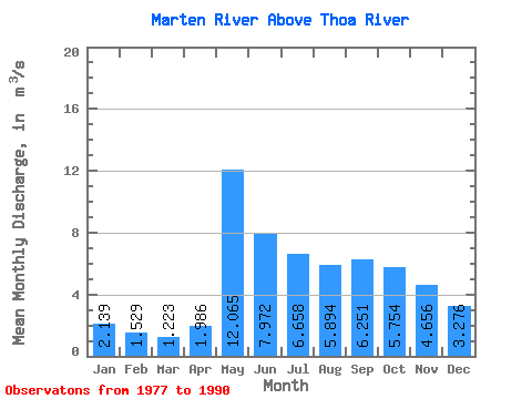
| Statistic | Jan | Feb | Mar | Apr | May | Jun | Jul | Aug | Sep | Oct | Nov | Dec | Annual |
|---|---|---|---|---|---|---|---|---|---|---|---|---|---|
| Mean | 2.14 | 1.53 | 1.22 | 1.99 | 12.06 | 7.97 | 6.66 | 5.89 | 6.25 | 5.75 | 4.66 | 3.28 | 5.05 |
| Standard Deviation | 0.62 | 0.51 | 0.46 | 1.61 | 6.53 | 2.60 | 3.33 | 3.75 | 3.27 | 2.47 | 1.53 | 1.07 | 1.37 |
| Min | 1.26 | 0.85 | 0.52 | 0.63 | 4.52 | 3.98 | 3.07 | 1.25 | 0.92 | 2.64 | 2.25 | 1.58 | 2.66 |
| Max | 3.16 | 2.38 | 1.86 | 5.98 | 25.30 | 12.70 | 13.70 | 13.90 | 11.80 | 11.00 | 7.93 | 5.02 | 7.46 |
| Coefficient of Variation | 0.29 | 0.33 | 0.37 | 0.81 | 0.54 | 0.33 | 0.50 | 0.64 | 0.52 | 0.43 | 0.33 | 0.33 | 0.27 |
 Return to R-Arctic Net Home Page