|
|
|||||||||||||||||
| Point ID: 3569 | Downloads | Plots | Site Data | Code: 07QC004 |
|
|
|||||||||||||||||
| Download | |
|---|---|
| Site Descriptor Information | Site Time Series Data |
| Link to all available data | |
| View: | Time Series | All |
| Units: | m3/s |
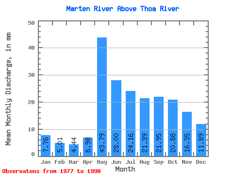
| Statistic | Jan | Feb | Mar | Apr | May | Jun | Jul | Aug | Sep | Oct | Nov | Dec | Annual |
|---|---|---|---|---|---|---|---|---|---|---|---|---|---|
| Mean | 7.76 | 5.06 | 4.44 | 6.97 | 43.78 | 28.00 | 24.16 | 21.39 | 21.95 | 20.88 | 16.35 | 11.89 | 216.02 |
| Standard Deviation | 2.25 | 1.67 | 1.66 | 5.66 | 23.71 | 9.14 | 12.09 | 13.59 | 11.50 | 8.97 | 5.37 | 3.88 | 58.73 |
| Min | 4.57 | 2.82 | 1.89 | 2.21 | 16.40 | 13.98 | 11.14 | 4.54 | 3.22 | 9.58 | 7.90 | 5.73 | 113.82 |
| Max | 11.47 | 7.87 | 6.75 | 21.00 | 91.81 | 44.60 | 49.71 | 50.44 | 41.44 | 39.92 | 27.85 | 18.22 | 318.81 |
| Coefficient of Variation | 0.29 | 0.33 | 0.37 | 0.81 | 0.54 | 0.33 | 0.50 | 0.64 | 0.52 | 0.43 | 0.33 | 0.33 | 0.27 |
 Return to R-Arctic Net Home Page