|
|
|||||||||||||||||
| Point ID: 3563 | Downloads | Plots | Site Data | Code: 07PA002 |
|
|
|||||||||||||||||
| Download | |
|---|---|
| Site Descriptor Information | Site Time Series Data |
| Link to all available data | |
| View: | Time Series | All |
| Units: | mm |
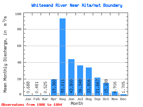
| Statistic | Jan | Feb | Mar | Apr | May | Jun | Jul | Aug | Sep | Oct | Nov | Dec | Annual |
|---|---|---|---|---|---|---|---|---|---|---|---|---|---|
| Mean | 0.69 | 0.48 | 0.53 | 19.36 | 93.01 | 43.80 | 36.35 | 33.81 | 21.67 | 15.19 | 4.92 | 1.71 | 20.78 |
| Standard Deviation | 0.41 | 0.32 | 0.41 | 10.52 | 20.83 | 21.98 | 21.90 | 22.45 | 12.54 | 9.82 | 2.41 | 0.92 | 5.61 |
| Min | 0.22 | 0.08 | 0.01 | 6.18 | 56.60 | 11.70 | 1.88 | 2.04 | 9.90 | 5.90 | 1.17 | 0.45 | 12.48 |
| Max | 1.44 | 1.11 | 1.43 | 33.70 | 129.00 | 71.00 | 66.20 | 74.20 | 45.80 | 33.80 | 8.42 | 3.05 | 27.80 |
| Coefficient of Variation | 0.59 | 0.66 | 0.78 | 0.54 | 0.22 | 0.50 | 0.60 | 0.66 | 0.58 | 0.65 | 0.49 | 0.54 | 0.27 |
 Return to R-Arctic Net Home Page