|
|
|||||||||||||||||
| Point ID: 3563 | Downloads | Plots | Site Data | Code: 07PA002 |
|
|
|||||||||||||||||
| Download | |
|---|---|
| Site Descriptor Information | Site Time Series Data |
| Link to all available data | |
| View: | Time Series | All |
| Units: | m3/s |
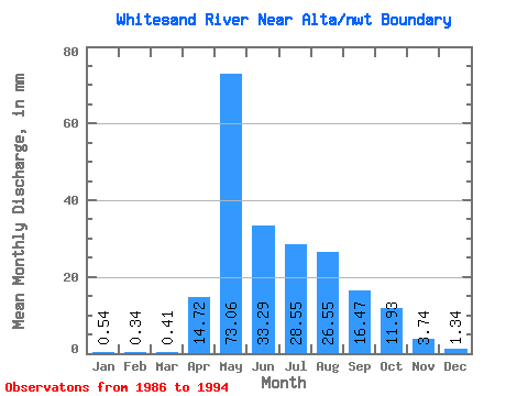
| Statistic | Jan | Feb | Mar | Apr | May | Jun | Jul | Aug | Sep | Oct | Nov | Dec | Annual |
|---|---|---|---|---|---|---|---|---|---|---|---|---|---|
| Mean | 0.54 | 0.34 | 0.41 | 14.72 | 73.05 | 33.29 | 28.55 | 26.55 | 16.47 | 11.93 | 3.74 | 1.34 | 192.34 |
| Standard Deviation | 0.32 | 0.23 | 0.32 | 8.00 | 16.36 | 16.71 | 17.20 | 17.63 | 9.54 | 7.71 | 1.83 | 0.72 | 51.89 |
| Min | 0.17 | 0.06 | 0.01 | 4.70 | 44.45 | 8.89 | 1.48 | 1.60 | 7.53 | 4.63 | 0.89 | 0.36 | 115.48 |
| Max | 1.13 | 0.79 | 1.12 | 25.62 | 101.31 | 53.97 | 51.99 | 58.27 | 34.81 | 26.54 | 6.40 | 2.40 | 257.34 |
| Coefficient of Variation | 0.59 | 0.66 | 0.78 | 0.54 | 0.22 | 0.50 | 0.60 | 0.66 | 0.58 | 0.65 | 0.49 | 0.54 | 0.27 |
 Return to R-Arctic Net Home Page