|
|
|||||||||||||||||
| Point ID: 3551 | Downloads | Plots | Site Data | Code: 06OA006 |
|
|
|||||||||||||||||
| Download | |
|---|---|
| Site Descriptor Information | Site Time Series Data |
| Link to all available data | |
| View: | Time Series | All |
| Units: | mm |
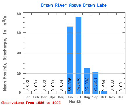
| Statistic | Jan | Feb | Mar | Apr | May | Jun | Jul | Aug | Sep | Oct | Nov | Dec | Annual |
|---|---|---|---|---|---|---|---|---|---|---|---|---|---|
| Mean | 0.00 | 0.00 | 0.00 | 0.00 | 0.00 | 66.04 | 75.57 | 25.03 | 21.61 | 2.93 | 0.09 | 0.00 | 15.91 |
| Standard Deviation | 0.00 | 0.00 | 0.00 | 0.00 | 0.01 | 39.42 | 49.45 | 14.56 | 14.84 | 2.37 | 0.13 | 0.00 | 1.94 |
| Min | 0.00 | 0.00 | 0.00 | 0.00 | 0.00 | 2.46 | 20.30 | 8.32 | 6.06 | 0.98 | 0.01 | 0.00 | 13.63 |
| Max | 0.00 | 0.00 | 0.00 | 0.00 | 0.03 | 124.00 | 163.00 | 51.00 | 55.20 | 8.19 | 0.43 | 0.01 | 19.84 |
| Coefficient of Variation | 2.25 | 0.60 | 0.65 | 0.58 | 0.69 | 0.81 | 1.50 | 3.00 | 0.12 |
 Return to R-Arctic Net Home Page