|
|
|||||||||||||||||
| Point ID: 3551 | Downloads | Plots | Site Data | Code: 06OA006 |
|
|
|||||||||||||||||
| Download | |
|---|---|
| Site Descriptor Information | Site Time Series Data |
| Link to all available data | |
| View: | Time Series | All |
| Units: | m3/s |
| Statistic | Jan | Feb | Mar | Apr | May | Jun | Jul | Aug | Sep | Oct | Nov | Dec | Annual |
|---|---|---|---|---|---|---|---|---|---|---|---|---|---|
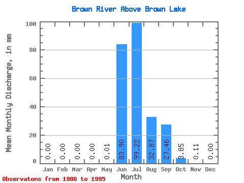
| Mean | 0.00 | 0.00 | 0.00 | 0.00 | 0.01 | 83.91 | 99.20 | 32.86 | 27.46 | 3.85 | 0.11 | 0.00 | 246.15 |
| Standard Deviation | 0.00 | 0.00 | 0.00 | 0.00 | 0.01 | 50.09 | 64.91 | 19.11 | 18.86 | 3.10 | 0.17 | 0.00 | 30.02 |
| Min | 0.00 | 0.00 | 0.00 | 0.00 | 0.00 | 3.13 | 26.65 | 10.92 | 7.70 | 1.28 | 0.02 | 0.00 | 210.91 |
| Max | 0.00 | 0.00 | 0.00 | 0.00 | 0.04 | 157.55 | 213.98 | 66.95 | 70.14 | 10.75 | 0.55 | 0.01 | 307.02 |
| Coefficient of Variation | 2.25 | 0.60 | 0.65 | 0.58 | 0.69 | 0.81 | 1.50 | 3.00 | 0.12 |
 Return to R-Arctic Net Home Page