|
|
|||||||||||||||||
| Point ID: 3536 | Downloads | Plots | Site Data | Code: 06LC003 |
|
|
|||||||||||||||||
| Download | |
|---|---|
| Site Descriptor Information | Site Time Series Data |
| Link to all available data | |
| View: | Time Series | All |
| Units: | mm |
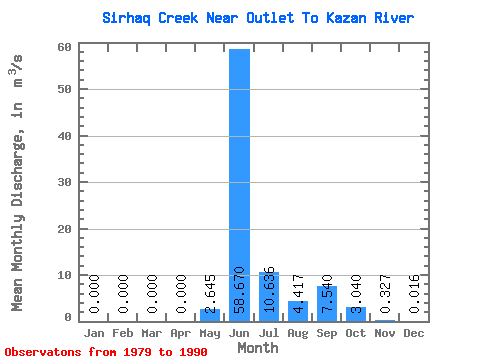
| Statistic | Jan | Feb | Mar | Apr | May | Jun | Jul | Aug | Sep | Oct | Nov | Dec | Annual |
|---|---|---|---|---|---|---|---|---|---|---|---|---|---|
| Mean | 0.00 | 0.00 | 0.00 | 0.00 | 2.65 | 58.67 | 10.64 | 4.42 | 7.54 | 3.04 | 0.33 | 0.02 | 9.06 |
| Standard Deviation | 0.00 | 0.00 | 0.00 | 0.00 | 5.58 | 29.52 | 4.74 | 3.38 | 7.48 | 2.46 | 0.28 | 0.04 | 1.44 |
| Min | 0.00 | 0.00 | 0.00 | 0.00 | 0.00 | 10.20 | 2.19 | 1.07 | 0.76 | 0.32 | 0.00 | 0.00 | 7.74 |
| Max | 0.00 | 0.00 | 0.00 | 0.00 | 16.90 | 96.30 | 18.40 | 10.20 | 24.60 | 8.02 | 0.88 | 0.11 | 11.74 |
| Coefficient of Variation | 2.11 | 0.50 | 0.45 | 0.76 | 0.99 | 0.81 | 0.85 | 2.44 | 0.16 |
 Return to R-Arctic Net Home Page