|
|
|||||||||||||||||
| Point ID: 3536 | Downloads | Plots | Site Data | Code: 06LC003 |
|
|
|||||||||||||||||
| Download | |
|---|---|
| Site Descriptor Information | Site Time Series Data |
| Link to all available data | |
| View: | Time Series | All |
| Units: | m3/s |
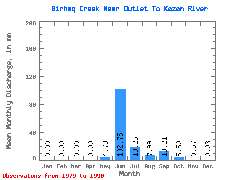
| Statistic | Jan | Feb | Mar | Apr | May | Jun | Jul | Aug | Sep | Oct | Nov | Dec | Annual |
|---|---|---|---|---|---|---|---|---|---|---|---|---|---|
| Mean | 0.00 | 0.00 | 0.00 | 0.00 | 4.79 | 102.75 | 19.25 | 7.99 | 13.21 | 5.50 | 0.57 | 0.03 | 193.21 |
| Standard Deviation | 0.00 | 0.00 | 0.00 | 0.00 | 10.10 | 51.69 | 8.57 | 6.11 | 13.11 | 4.45 | 0.49 | 0.07 | 30.74 |
| Min | 0.00 | 0.00 | 0.00 | 0.00 | 0.00 | 17.86 | 3.96 | 1.94 | 1.34 | 0.57 | 0.00 | 0.00 | 164.99 |
| Max | 0.00 | 0.00 | 0.00 | 0.00 | 30.58 | 168.66 | 33.29 | 18.46 | 43.08 | 14.51 | 1.55 | 0.20 | 250.43 |
| Coefficient of Variation | 2.11 | 0.50 | 0.45 | 0.76 | 0.99 | 0.81 | 0.85 | 2.44 | 0.16 |
 Return to R-Arctic Net Home Page