|
|
|||||||||||||||||
| Point ID: 345 | Downloads | Plots | Site Data | Code: 05BN006 |
|
|
|||||||||||||||||
| Download | |
|---|---|
| Site Descriptor Information | Site Time Series Data |
| Link to all available data | |
| View: | Time Series | All |
| Units: | mm |
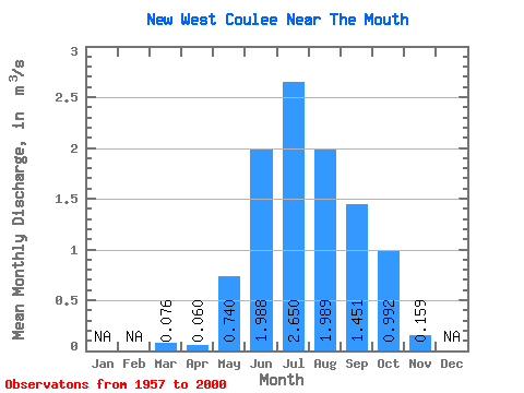
| Statistic | Jan | Feb | Mar | Apr | May | Jun | Jul | Aug | Sep | Oct | Nov | Dec | Annual |
|---|---|---|---|---|---|---|---|---|---|---|---|---|---|
| Mean | 0.08 | 0.06 | 0.74 | 1.99 | 2.65 | 1.99 | 1.45 | 0.99 | 0.16 | ||||
| Standard Deviation | 0.10 | 0.07 | 0.68 | 0.96 | 1.10 | 1.04 | 0.91 | 0.74 | 0.14 | ||||
| Min | 0.00 | 0.00 | 0.00 | 0.39 | 0.42 | 0.20 | 0.08 | 0.21 | 0.06 | ||||
| Max | 0.26 | 0.27 | 2.85 | 4.28 | 4.28 | 4.17 | 3.71 | 2.77 | 0.26 | ||||
| Coefficient of Variation | 1.31 | 1.14 | 0.92 | 0.48 | 0.42 | 0.52 | 0.63 | 0.75 | 0.87 |
 Return to R-Arctic Net Home Page