|
|
|||||||||||||||||
| Point ID: 345 | Downloads | Plots | Site Data | Code: 05BN006 |
|
|
|||||||||||||||||
| Download | |
|---|---|
| Site Descriptor Information | Site Time Series Data |
| Link to all available data | |
| View: | Time Series | All |
| Units: | m3/s |
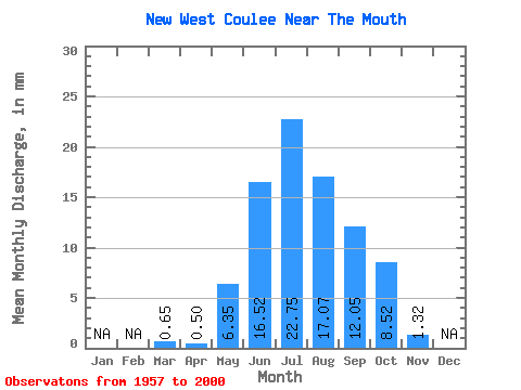
| Statistic | Jan | Feb | Mar | Apr | May | Jun | Jul | Aug | Sep | Oct | Nov | Dec | Annual |
|---|---|---|---|---|---|---|---|---|---|---|---|---|---|
| Mean | 0.65 | 0.50 | 6.35 | 16.51 | 22.75 | 17.07 | 12.06 | 8.52 | 1.32 | ||||
| Standard Deviation | 0.85 | 0.57 | 5.86 | 7.98 | 9.48 | 8.93 | 7.59 | 6.36 | 1.15 | ||||
| Min | 0.00 | 0.01 | 0.01 | 3.24 | 3.60 | 1.68 | 0.70 | 1.77 | 0.51 | ||||
| Max | 2.24 | 2.27 | 24.46 | 35.56 | 36.74 | 35.79 | 30.82 | 23.78 | 2.13 | ||||
| Coefficient of Variation | 1.31 | 1.14 | 0.92 | 0.48 | 0.42 | 0.52 | 0.63 | 0.75 | 0.87 |
 Return to R-Arctic Net Home Page