|
|
|||||||||||||||||
| Point ID: 339 | Downloads | Plots | Site Data | Code: 05BM018 |
|
|
|||||||||||||||||
| Download | |
|---|---|
| Site Descriptor Information | Site Time Series Data |
| Link to all available data | |
| View: | Time Series | All |
| Units: | mm |
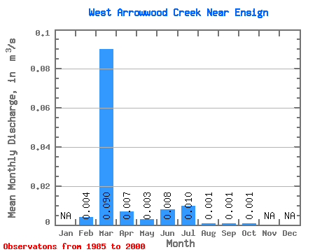
| Statistic | Jan | Feb | Mar | Apr | May | Jun | Jul | Aug | Sep | Oct | Nov | Dec | Annual |
|---|---|---|---|---|---|---|---|---|---|---|---|---|---|
| Mean | 0.00 | 0.09 | 0.01 | 0.00 | 0.01 | 0.01 | 0.00 | 0.00 | 0.00 | ||||
| Standard Deviation | 0.01 | 0.20 | 0.02 | 0.00 | 0.02 | 0.03 | 0.00 | 0.00 | 0.00 | ||||
| Min | 0.00 | 0.00 | 0.00 | 0.00 | 0.00 | 0.00 | 0.00 | 0.00 | 0.00 | ||||
| Max | 0.03 | 0.69 | 0.06 | 0.01 | 0.06 | 0.12 | 0.01 | 0.01 | 0.01 | ||||
| Coefficient of Variation | 2.60 | 2.23 | 2.18 | 1.08 | 1.98 | 3.31 | 1.77 | 1.67 | 1.57 |
 Return to R-Arctic Net Home Page