|
|
|||||||||||||||||
| Point ID: 339 | Downloads | Plots | Site Data | Code: 05BM018 |
|
|
|||||||||||||||||
| Download | |
|---|---|
| Site Descriptor Information | Site Time Series Data |
| Link to all available data | |
| View: | Time Series | All |
| Units: | m3/s |
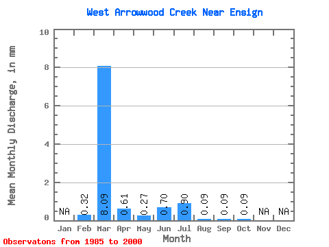
| Statistic | Jan | Feb | Mar | Apr | May | Jun | Jul | Aug | Sep | Oct | Nov | Dec | Annual |
|---|---|---|---|---|---|---|---|---|---|---|---|---|---|
| Mean | 0.29 | 8.09 | 0.62 | 0.31 | 0.72 | 0.87 | 0.10 | 0.08 | 0.12 | ||||
| Standard Deviation | 0.77 | 18.07 | 1.35 | 0.34 | 1.44 | 2.87 | 0.17 | 0.14 | 0.19 | ||||
| Min | 0.00 | 0.00 | 0.00 | 0.00 | 0.00 | 0.00 | 0.00 | 0.00 | 0.00 | ||||
| Max | 2.62 | 61.94 | 5.39 | 0.99 | 5.39 | 11.24 | 0.45 | 0.43 | 0.72 | ||||
| Coefficient of Variation | 2.60 | 2.23 | 2.18 | 1.08 | 1.98 | 3.31 | 1.77 | 1.67 | 1.57 |
 Return to R-Arctic Net Home Page